If you’re planning a trip to Zion, you already know the landscape is something else. But knowing which trail to tackle – and when – makes the difference between a great day and a brutal one. These are the best hikes near Zion National Park, ranked by difficulty so you can plan your days like a local, not a tourist.
Easy Hikes
Riverside Walk
Distance: 2.2 miles round trip | Elevation Gain: 57 ft
This paved trail follows the Virgin River through the Zion Narrows canyon bottom – it’s the gateway hike to The Narrows and stunning on its own. The canyon walls close in around you as you walk, with cottonwoods overhead and the river on your right. Accessible year-round and stroller-friendly, it’s the easiest introduction to what makes Zion special.
Pro Tip: Go early morning for golden light on the canyon walls and fewer crowds. This is also the starting point if you plan to wade into The Narrows.
Canyon Overlook Trail
Distance: 1 mile round trip | Elevation Gain: 163 ft
Short, sweet, and delivers one of the best views in the park for minimal effort. The trail starts just east of the Zion-Mt. Carmel Tunnel and winds along ledges above Pine Creek Canyon. You’ll get sweeping views of the canyon floor and the white Navajo sandstone cliffs without breaking a serious sweat.
Pro Tip: Park at the small lot just east of the tunnel – it fills fast. Get there before 8am or arrive after 4pm. No shuttle needed; you drive to this trailhead.
Moderate Hikes
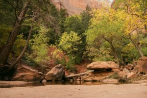
Emerald Pools
Distance: 1.2-3 miles (Lower to Upper Loop) | Elevation Gain: Up to 350 ft
Three tiers of pools, waterfalls, and hanging gardens carved into the red rock. The Lower Pool is an easy stroll; the Middle and Upper pools add elevation and reward with progressively better views and fewer people. The trail weaves between desert and riparian zones – you’ll pass under a waterfall curtain on the way to the lower pool.
Pro Tip: Do the full loop – Lower, Upper, then back via the Kayenta Trail – for the best overall experience. It’s worth the extra half mile.
Hidden Canyon
Distance: 2.4 miles round trip | Elevation Gain: 850 ft
This one earns its “moderate” label. The trail climbs steeply up the canyon wall via carved stone steps and ends in a narrow, slot-like canyon that most visitors never reach. It feels remote even on a busy park day. The final push to the canyon entrance involves a brief chain-assist section on exposed ledges – nothing technical, but it gets your attention.
Pro Tip: Wear grippy shoes. The sandstone can be deceptively slick, especially after rain. This trail closes when wet.
Ready to explore? Book your basecamp at Zion’s Tiny Getaway – 30-minutes from the park entrance. Wake up close to the trailhead and skip the 5am alarm from St. George.
Hard / Strenuous Hikes
Angels Landing
Distance: 5.4 miles round trip | Elevation Gain: 1,488 ft
The most iconic hike in Zion – and one of the most dramatic in the American West. The trail climbs relentlessly up Walter’s Wiggles (21 switchbacks cut directly into the rock face), then follows a narrow fin of sandstone to the summit with 1,000-foot drops on both sides. Chains are bolted into the rock for the final half mile. The views from the top are worth every step.
Pro Tip: A permit is now required for the chains section (lottery-based through recreation.gov). Book months in advance. Go on a weekday in shoulder season if you can – spring and fall mornings are ideal.
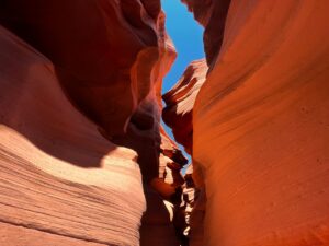
The Narrows (Top-Down)
Distance: Up to 16 miles one way | Elevation Gain: 334 ft loss
Wading, sometimes chest-deep, through the Virgin River inside a slot canyon that’s as narrow as 20 feet wide – this is the Narrows experience. The top-down route from Chamberlain’s Ranch is a full-day permit trip; the bottom-up walk from Riverside Walk is doable without permits and still extraordinary. The canyon walls tower over 1,000 feet and block the sky entirely.
Pro Tip: Rent dry pants, neoprene socks, and a walking stick from outfitters in Springdale. Do not attempt this hike if the forecast shows any upstream rain – flash flood risk is real.
Observation Point
Distance: 8 miles round trip | Elevation Gain: 2,148 ft
The hardest and most rewarding summit hike in Zion. Observation Point sits 2,000 feet above the canyon floor and puts Angels Landing directly below you. The route climbs through Echo Canyon – a narrow slot section midway – before breaking out onto open mesa. It’s long, exposed, and magnificent.
Pro Tip: Start before sunrise. The upper section is fully exposed and brutal in midday heat. Bring 3+ liters of water minimum. The East Mesa alternate route (starting outside the park) avoids most of the elevation gain if you want the view without the full climb.
📍 Planning your visit? Read our month-by-month guide to the best time to visit Zion to pick the right season for your hiking goals. And if Angels Landing is on your list, check our complete Angels Landing permit and difficulty guide before you apply for the lottery.
The Bottom Line
Zion rewards the prepared. Know your fitness level, check trail conditions before you go, and get on the road early – the park’s single canyon road gets choked by 9am in peak season. Whether you’re doing a leisurely riverside stroll or grinding up to Observation Point at dawn, every trail here punches above its weight.
The best way to experience all of it? Stay close. Book your basecamp at Zion’s Tiny Getaway – 30-minutes from the park entrance. Your own private tiny home, a killer basecamp setup, and zero excuse not to be on the trail by first light.